Category: Uncategorized

  • AlphaEarth Foundations: Where AI Meets Earth Observation for Unmatched Detail

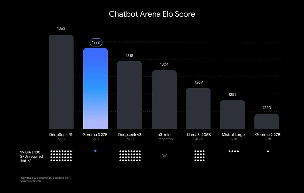
    🤯 This incredible image showcases the stunning beauty and diversity of the African continent, generated using the new AlphaEarth Foundations dataset on Google Earth Engine. So what is this dataset all about? 

    Imagine being able to X-ray the entire Earth across multiple years, even seeing through clouds! Dealing with clouds in remote sensing is a huge challenge (something I know well from my Open Buildings research project). The AlphaEarth team has essentially created a “virtual satellite” capable of doing just that. To achieve this, the AlphaEarth team combined vast amounts of data from dozens of public sources, including optical satellite images, radar, 3D laser mapping, etc.. weaving it all into a seamless picture.

    Even after just a few minutes of exploring the dataset, I’ve stumbled upon fascinating insights. For example, why have Central Mali or Lake Kalala in Zambia changed so much? There’s likely a clear explanation, though I don’t know it yet.

    This open dataset release is a huge step forward, likely to help scientists and experts make more informed decisions on critical global issues like food security, deforestation, urban expansion, and water resources.

    If you think you can leverage this dataset for your research on our changing world, consider applying for the Satellite Embedding Grant. (Link below)

    Paper: https://storage.googleapis.com/deepmind-media/DeepMind.com/Blog/alphaearth-foundations-helps-map-our-planet-in-unprecedented-detail/alphaearth-foundations.pdf

    Google Deepmind Blog: https://deepmind.google/discover/blog/alphaearth-foundations-helps-map-our-planet-in-unprecedented-detail/

    Google Earth blog: https://medium.com/google-earth/ai-powered-pixels-introducing-googles-satellite-embedding-dataset-31744c1f4650

    Demo: https://code.earthengine.google.com/?scriptPath=Examples%3ADatasets%2FGOOGLE%2FGOOGLE_SATELLITE_EMBEDDING_V1_ANNUAL

    Dataset: https://developers.google.com/earth-engine/datasets/catalog/GOOGLE_SATELLITE_EMBEDDING_V1_ANNUAL

    Grant application: https://docs.google.com/forms/d/e/1FAIpQLSfxnmqM2PEKdphTWXh44jsy83SRBkn0grjg6shRS-mLJTsKrQ/viewform

    Google Earth Engine screenshot showing world embeddings of 2024.
    Screenshot of Google Earth Engine showing similarities between years. (white spots are where most changes happened.
    Changes in central Mali
    Changes at Lake Kalala, Zambia
  • TxGemma Release: AI Models for Therapeutics Development 🧪🔬

    Google DeepMind has released TxGemma, a set of open-weight AI models designed for therapeutic development. These models, based on the Gemma architecture, are trained to analyze and predict characteristics of therapeutic entities during drug discovery. 💊

    The release includes ‘chat’ variants (9B and 27B) that can engage in dialogue and provide explanations for their predictions. Additionally, Agentic-Tx demonstrates the integration of TxGemma into an agentic system for multi-step research questions. 🤖

    A fine-tuning notebook is available for custom task adaptation:

    Execution is possible on a free T4 GPU after license acceptance and Hugging Face token provision:

    If you encounter issues with the provided fine-tuning notebook, you can check my pre-configured Colab notebook:

    Further resources:

    Credit for this release: Shekoofeh Azizi and other contributors. 🎉

  • Gemma 3: Massive Context, 35+ Languages, and Multimodal Capabilities

    🚨 Gemma 3 is out! It’s a family of open AI models (1B-27B parameters) featuring a 128k token context window (can work with very long documents and conversations), multilingual support (35+ languages, trained on 140+), and single GPU/TPU compatibility. I’m excited about its potential to increase accessibility to advanced AI models, especially in resource-constrained settings, and the multimodal capabilities that can enable diverse applications.

    Blog: https://blog.google/technology/developers/gemma-3/

    Technical report: https://storage.googleapis.com/deepmind-media/gemma/Gemma3Report.pdf

    Developer guide: https://developers.googleblog.com/en/introducing-gemma3/

  • Spatial Queries on Hout Bay Data Using Gemini ‘s DataScience Agent

    I tested the Gemini Datascience agent with the Hout Bay (Cape Town, South Africa) building data footprint, asking simple spatial questions, “show me small houses” and “identify crowded areas” “what about large houses with few neighbors”. The agent generates interesting visualizations and can select various algorithms, for example it picked k-Nearest Neighbors (k-NN) to detect houses with adjacent neighbors. I spent wayyy too much time on this, but I really liked the interactive aspect to make refinements iteratively by just making suggestions and asking for alternatives, kind of chatting with a Datascience expert :). I guess you would call this Conversational geospatial data analysis?